


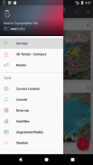
Mobile Topographer GIS


Perihal Mobile Topographer GIS
Pilihan dicintai oleh profesional,
Topographer Mobile ... bertemu dengan ...
GIS .
Anda kini boleh melakukan kajian yang lengkap tanpa apa-apa batasan ke dalam kerumitan atau jumlah data.
Cuba sekarang Mobile Topographer GIS dengan menggunakan tiga hari tempoh percubaan percuma. Hanya memuat turun aplikasi dan teruskan dengan dia prosedur langganan. Walaupun, anda akan diminta untuk menyediakan maklumat bil, anda TIDAK akan dikenakan sebelum akhir tiga hari tempoh percubaan percuma. Anda boleh membatalkan langganan anda pada bila-bila masa dalam tempoh percubaan tiga hari, secara percuma. Caj hanya akan berlaku, jika pada akhir tiga hari kamu masih mempunyai langganan aktif.
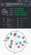
- Mengumpul bacaan GNSS menggunakan ketepatan meningkat (GPS, GLONASS, Galileo, Beidou, buruj QZSS disokong).
- Menyambung GNSS penerima luaran melalui lokasi olok-olok dan menggunakan Mobile Topogrpaher GIS sebagai unit pemprosesan.
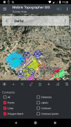
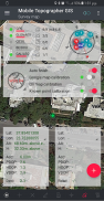
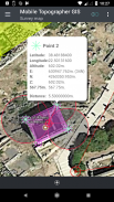
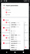
- Data Display ke dalam CRS WGS84 atau anda tempatan diunjurkan.
- Tukar dari WGS84 ke tempatan diunjurkan CRS dan sebaliknya.
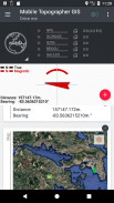
- Real unjuran masa pada peta.
- *** NEW *** imej tempahan atau pelayan WMS sebagai peta latar belakang.
- Cari tempat yang ketara dalam dunia sebenar dengan menggunakan "Memandu saya"
- ketinggian Kira ortometrik dengan cepat menggunakan model EGM atau grid ketinggian tempatan apabila boleh didapati.
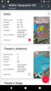
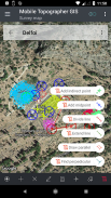
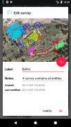
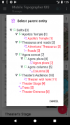
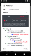
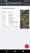
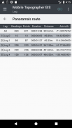
- Menganjurkan kerja anda ke dalam Mata - Bentuk - Entiti & Surveys. Anda kini boleh membuat mata individu, kumpulan berbilang titik, polylines berbilang dan poligon berbilang bahagian dengan lubang.
- Buat lukisan penuh dengan butiran seberapa banyak yang anda mahu.
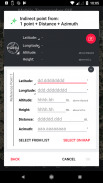
- *** NEW *** alat geodetik. Menambah mata tidak langsung secara atas daripada pilihan yang berikut: 1 mata + Jarak + Azimuth, 2 mata + Jarak + Pilih, 2 mata + Azimuths, 3 mata + Jarak, Titik tengah barisan, barisan Divide, Panjangkan talian, talian selari, Perpendicular beratur .
- Nest pekerjaan anda, dalam mana-mana peringkat bersarang, untuk mewujudkan super-kajian.
- Kongsi data antara pekerjaan dengan pautan aktif.
- Exchange pekerjaan antara peranti mudah alih dan komputer desktop anda, dengan import - fungsi eksport menggunakan semua format biasa .txt, .csv, .kml, .gpx, .dxf dan bentuk fail (.shp - .shx - .dbf)
- Bekerjasama dengan rakan-rakan anda dengan bertukar-tukar dan berkongsi dari satu titik untuk melengkapkan kerja.
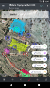
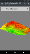
- Buat rupa bumi 3D di satu-satu kawasan hanya berjalan melaluinya.
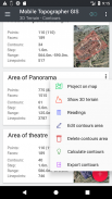
- Kira kontur dan menambah mereka ke dalam kaji selidik anda dengan kelajuan kilat.
- Lihat model 3D terus ke peranti anda.
- Simpan laluan dengan datanya.
- satelit Tunjuk GNSS dengan maklumat isyarat dalam kedua-dua pandangan kompas atau AR.
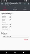
- Backup dan memulihkan data anda menggunakan fail SQL .db.
Selamat datang ke era ukur bimbit ...!
Cari lebih lanjut mengenai Mobile Topographer GIS dalam:
http://applicality.com/projects/mobile-topographer-gis/
Muat turun manual pengguna daripada:
http://applicality.com/app_documentation/web/MobileTopographerGIS_Manual.pdf


Mobile Topographer GIS - Maklumat APK
Versi APK: 6.0.15Pakej: com.applicality.mobiletopographergisVersi Terkini Mobile Topographer GIS
Versi lain


 4.34
4.34
Aplikasi dalam kategori sama

Anda juga mungkin suka...


